Thunderstorms are one of the most beautiful atmospheric phenomenon. As a pilot, however, thunderstorms are one of the most hazardous conditions you can encounter. Thunderstorms can produce severe turbulence, low level wind shear, low ceilings and visibilities, hail and lightning. Each of these hazards can be difficult to cope with; if all these conditions arrive at once, it can be disastrous. Understanding basic thunderstorm formation and structure can help you make safe decisions.
Thunderstorms are formed by a process called convection, defined as the transport of heat energy. Because the atmosphere is heated unevenly, an imbalance can occur which thunderstorms attempt to correct. Three things are needed for convection to be a significant hazard to flight safety: moisture, lift and instability.
Moisture—Sufficient moisture must be present for clouds to form. Although convection occurs in the atmosphere without visible clouds, think thermals on a warm afternoon, moisture not only is the source of a visible cloud, but also fuels the convection to continue. As the warm air rises, it cools, and the water vapor in the air condenses into cloud droplets. The condensation releases heat, allowing the rising air to stay buoyant and continue to move upward.
Lift—There are many ways for air to be lifted in the atmosphere. Convection, or buoyancy, is one method. Other meteorological methods include fronts, low pressure systems, interactions between thunderstorms, and interactions between the jet stream and the surface weather systems. Air also can be lifted by mechanical lift, such as when it is forced up and over a mountain range. Regardless of how the air is lifted, if the lift is enough to make the air warmer than the surrounding air, convection can continue.Next, We’ll look at the thunderstorm outflow boundary, which can have a significant impact on aviation. This boundary marks the leading edge of rain-cooled air flowing out from mature thunderstorms.
Instability—In general, as you increase in altitude, the air temperature cools up to the top of the troposphere. Of course, around fronts, mountains and in shallow layers near the ground, this is not always the case. How fast air cools is a measure of atmospheric stability. Meteorologists refer to this vertical change in temperature as the lapse rate. Outside of extremes, the temperature generally decreases from between 2.7oF – 5.4oF per 1000 feet. If the actual rising air cools slower than the lapse rate, the air remains relatively warmer than the surrounding air and it continues to rise.
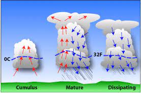
Three Stages of Thunderstorms
Towering Cumulus Stage: This is the stage of a thunderstorm once convection has begun and a cloud is visible. These building clouds are made entirely of liquid water. This stage is characterized by upward motion throughout the entire cloud. Aviation hazards from this stage include turbulence and icing. Even though the cloud is composed of all liquid, some of the liquid is “supercooled,” in other words, liquid water can exist at temperatures below the normal freezing point.

Mature Stage: This stage is characterized by the production of precipitation. Both updrafts and downdrafts are present. Lightning is being produced. The mature thunderstorm contains water, supercooled water and ice.

Dissipating Stage: During this final stage, the updraft has ceased and the storm is dominated by downdrafts. Precipitation may still occur, but will decrease with time as moisture is depleted. This dissipating thunderstorm contains mostly ice.

You can visually estimate the potential for convection to continue by looking at the texture of the thunderstorms. If the cumulus tops are crisp and well defined—often looking like a cauliflower, the storm will continue to grow. The crisp texture occurs because the cloud is mostly made up of water drops with little ice. As the storm becomes more vertical, these water drops will change phase and freeze. This change will release heat, fueling the continued growth of the cloud.
If the clouds appears fuzzy, it is likely because they are now composed mostly of ice crystals As a result, the storm has much less energy available to grow significantly taller. Individual thunderstorms generally last less than one hour; however, if the storms are being continually forced by a moving front outflow boundary or from the same terrain feature and area, thunderstorms can continue for many hours.
A special case of thunderstorms are known as supercell thunderstorms. Supercell thunderstorms have a structure, driven primarily by the changing wind speed and direction with height that allows the updrafts and downdrafts to remain separated. Thus, the storm can remain in the mature phase for extended periods—several hours or more. These supercell thunderstorms are often times associated with damaging winds, frequent lightning, large hail, severe to extreme turbulence, and low level wind shear.
Pre-Flight Preparation
As a pilot, your Pre-flight preparation should include determining forecast and actual weather conditions for the route planned and for the selected airfields along the route.
En-route weather comprises forecast winds and temperatures at cruising levels along the route together with forecasts of en-route weather conditions, especially cloud conditions and any associated turbulence and/or icing. This information is depicted on special charts.

Airfield weather reports may be either actual reports (Meteorological Terminal Air Report (METAR)) or forecast conditions (TAF). METARs are issued at regular intervals; when a significant change to conditions occurs before the next METAR is due, a special report (SPECI) is issued. In the interests of brevity and clarity, written METARs, SPECIs and TAFs always follow the same format and employ simple self-evident codes. Lets look at some examples TAFs and review our knowledge.
- BIKF 201045Z 2012/2112 15012KT 9999 FEW025 BKN035 BECMG 2020/2022 VRB02KT. BECMG 2109/2112 33010KT
The BECMG group allows a forecaster to infer a gradual or not so gradual change over a period of usually 2 hours. For example, on the TAF above, the wind, as of 2200 UTC, is variable at 2 knots. On the last line, the BECMG group indicates that sometime between 0900 and 1200 UTC on the 21st the winds would change. As of the 1200 UTC, the winds would be from the northwest at 10 knots. The BECMG group usually includes only the weather element that changes.
2. EDDB 201100Z 2012/2112 27015G25KT 9999 SCT020 BECMG 2012/2014 28010KT. PROB30. TEMPO 2014/2018 SHRA BECMG 2018/2020 25005KT
TEMPO: indicates frequent or infrequent temporary fluctuations in forecast meteorological conditions expected to last less than 1 hour in each instance and, in the aggregate, cover less than half of the period indicated. Since above TAF is a 4-hour period the total time of showers should be less than 2 hours. If this was only a TEMPO group, you would look for a greater than 50% chance of the showers.
PROB: indicates the probability of occurrence of forecast element(s) during a defined period of time. Only the values 30 and 40 are used to indicate the probabilities of 30% and 40%, respectively. In the TAF above, the PROB30 remark preceding TEMPO, which means that there is only a 30 percent chance of the airport getting a shower. Having said that, if they get the shower, then it will be an on-and-off, 4-hour event as defined by the TEMPO rules above.
In TAF or METAR current weather is constructed sequentially – Intensity, Descriptor, Precipitation (dominant type is reported first if more than one type reported), Obscuration and Other and following this would further help you in decoding it.
Satellite picture available in various formats like Infrared, Visible or moisture will help you assess the probability of formation of thunderstorms. More often you look at these pictures more accurate your prediction would become and better off you would be.
Forewarned is Forearmed. Take no risk and be alert to danger. That is all.