CLEAR AIR TURBULENCE
In an otherwise uneventful flight, suddenly ‘Fasten Seat Belts’ sign came up with no clouds visible to us from our window, the sign stayed on for some time and then they go off. It did leave my wife wondering why the seat belts sign came up in the first place and then they go off, with nothing happening except a disruption in the in-flight services. Well unknown to us in all probability the captain put the ‘Fasten Seat belts’ sign on because he/she expected a rough flight which could potentially spill the drinks, throw off the passengers off their seats may be resulting injuries to some of the flight crew or passengers. After all, those blokes in the cockpit have only one mission that is, your safety.
In other words the captain of your aeroplane expected to encounter clear air turbulence popularly called CAT. Some passengers refer to it as hitting an air pocket also. Well, you can be sure that there are no empty spaces (pockets) in the literal sense in the atmosphere, yes there are pockets which can suddenly throw a nasty surprise on the pilot by giving severe jolts to the aircraft strong enough to make it impossible to control the aircraft for a few seconds. As the name suggests CAT is turbulence or bumpiness experienced in clear air i.e. there are no clouds present. CAT is now referred to as turbulence outside of a thunder cloud above 15000’. It is this fact i.e absence of clouds that make this phenomenon impossible to see and therefore dangerous to the safety of the passengers. The absence of the clouds means that there are no visual signs to warn the pilot of the impending turbulence. Turbulence or bumpiness is usually defined as Light/ moderate/severe and Extreme.
Light turbulence may cause unsecured objects to be displaced slightly; foodservice easily conducted and there is no difficulty in walking. Turbulence is called Moderate when unsecured objects are dislodged; food serving and walking becomes difficult. Change in altitude or attitude of the aircraft. However, aircraft remains in positive control all the time; variations in indicated airspeed are seen. Turbulence is called Severe when food serving and walking is impossible. There are large abrupt changes in attitude and or altitude. Large variations occur in indicated airspeed, aircraft may be momentarily out of control. In extreme turbulence, aircraft is violently tossed about and is possibly impossible to control. It may cause structural damage to the aircraft. Extreme turbulence is experienced inside or in association with a thunder cloud i.e. a Cumulonimbus cloud (Cb cloud). Thus CAT encountered in a otherwise smooth flight can be light/mod or severe.
Turbulence can be caused by a thunder cloud, mountain waves and CAT. Thunder cloud can be seen or detected on airborne Radar sufficiently well in advance to avoid it. Mountain waves occur on the lee side of a mountain and can be avoided.
It is the CAT which is not detectable and is a problem. But why does it occur? To understand that let us understand some basics of science. The wind is defined as air in a horizontal motion. An aircraft is very precisely engineered machine to fly in the wind and achieve a balance between various forces acting on an aircraft i.e. thrust drag, lift and gravity. When all the forces are in balance the aircraft will fly smoothly at the desired level and the power settings will achieve the desired speed with a perfect balance between lift and gravity. Power settings of the aircraft, angle of attack direction etc all are controlled by the captain or autopilot as the case may be. There is only one factor that is not under the control of the pilot and that is the medium through which the aircraft is flying, the winds. We can’t see the atmosphere, but it is nothing but an ocean of gases. We can see an ocean because a large body of water is visible but the air is not. If you are sailing on a ship, from the deck you can see the waves, small and large cancelling out or amplifying each other. But aircraft is like a submarine flying inside the ocean of air rather than at it and the rapid variations occurring in the properties of air are not visible viz density, temperature, speed etc. Aircraft are designed to fly in the wind i.e. air particles in a horizontal motion. But in nature air does not always flow in a smooth horizontal motion.
The atmosphere is laminar in structure and the air is a bad conductor of heat. To understand the laminar structure of the atmosphere, visualize a book and a block of wood. The block of wood is one piece with uniform physical properties i.e it is one unit. On the other hand, a book is made of a number of sheets of paper having different physical properties. Some papers in the book might have come from different mills having different thickness, different values of electrical and /or thermal conductivity, that is each leaf behaves on its own and not exactly like the leaf above it or below it and of course, it will not share its physical properties with the other leaves of the book. The atmosphere is made like a book with different layers of air on top of each other having, different temperatures and therefore density, flowing over each other. Remember wind by definition is air in a horizontal motion. At the ground level, wind speed could be five knots and at a flight level of 300, it could be 100kt and not necessary in the same direction as at that surface. The change in wind vector (change in direction or speed of the wind with height or in the horizontal) is called wind shear. The effect of wind shear is that it causes friction amongst the different layers of the atmosphere. A lower layer moving at a slower speed will try to drag the layer above it backwards, similarly, a layer above it moving at a higher speed will try to drag the layer below it along with it. A body i.e.an air particle in this case moving at a certain speed has a certain amount of kinetic energy due to its speed. When it is being dragged back its speed will decrease resulting in a decrease of its kinetic energy. The laws of conservation of energy tell us that the total energy of a moving particle remains constant, in other words, the sum of kinetic energy and potential energy will remain constant. Therefore when the kinetic energy decreases it will increase the potential energy. Kinetic energy is due to speed and is given by ½ mv2 and potential energy is given by mgh i.e mass x acceleration due to gravity x height. Now mass and acceleration due to gravity are constant, therefore a reduction in speed will induce a height gain. This means instead of moving in a horizontal direction the air particles will try to move up, acquiring a vertical velocity. A vertical wind speed i.e. updraft or a downdraft will increase or decrease the lift experienced by the aircraft, resulting in bumpiness like a light boat sailing over the waves. When this shear increases beyond a certain value it will lead to a breakdown of the smooth flow of the wind causing aircraft to experience turbulence. Along with the change in wind speed, there is a change in the temperature of the air in the vertical as well as in the horizontal. The change in temperature with distance is called the temperature gradient. A higher temperature gradient means a rapid change in the density of the air resulting in a higher amount of friction amongst different layers of the atmosphere. All the factors combined can lead to a breakdown of smooth flow of air causing turbulence, the faster the changes more severe the turbulence.
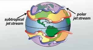
In general, the wind speed increases with height and reaches a maximum value just below the tropopause which is the end of the troposphere, (the layer above which weather will not occur) but most of the flying takes place in this layer of the atmosphere. The atmosphere has different streams of air moving within it. As we go up the wind speed generally increase and if at a point when the wind speed equals or exceeds 60 kt, it is called a Jet Stream. The wind speed in a Jet stream can be as high 300kts, but 60 kt is the lower threshold. Such strong winds build up in the atmosphere due to various reasons, and one among them is a strong temperature gradient i.e. a rapid change in temperature with distance. This gives rise to build up of strong thermal wind which will give rise to winds of Jet stream strength. Jet streams are strong winds circulating around the globe generally in a West to East direction.
At any given time there will be a minimum of two Jet streams circulating around the globe in each hemisphere. There is an East to West moving Jet stream also and is called Tropical Easterly Jet. This Jet stream in encountered over Southern India during the monsoon season. The other Jet Stream appearing over India is Sub Tropical Jet Stream, which is westerly Jet i.e. moving from West to East. This Jet Stream is seen over N India from October to May. Jet streams in winter are stronger than in summer. When such strong winds are build up, it naturally follows that there will be an associated wind shear giving rise to turbulence. CAT, that is turbulence experienced above 15000 feet outside of CB clouds is, therefore, more likely to be encountered in association with a Jet stream. The fringes of Jet Stream are a potential area to expect CAT. CAT is not experienced in the core of the Jet stream. Therefore flying over India one is more likely to experience CAT in winter over Northern India. The main problem with CAT is that it is a localized, random, patchy, sporadic and a transient phenomenon. An aircraft may experience CAT at a particular place but an aircraft flying ten minutes later at the same spot may experience nothing or may come across CAT a 100km away. Therefore it is practically impossible to forecast CAT. Met offices based on charts are likely to delineate areas where CAT can be expected in their route forecasts. Therefore an aircraft flying in that CAT prone areas will take precautions on the first signs of encountering roughness or maybe even before it. It is because of this precautionary measures that you are asked to fasten your seat belts even though there is no weather. Clear-air turbulence is usually impossible to detect with the naked eye and very difficult to detect with a conventional radar, with the result that it is difficult for aircraft pilots to detect and avoid it.
Israeli Air Force has got an air defence system called Aerostar, wherein a radar is put inside a huge tethered balloon and balloon is kept afloat up to about 15000 ft AMSL, this gives them eyes deep into enemy territory. To safeguard this radar against weather a Doppler Weather Radar is installed on-site to detect thunderstorms and another equipment called Wind Profiler is also installed there. The wind profiler can warn of the likely build-up of turbulence on site. As and when the turbulence is building up the airborne radar is pulled down to earth or at a safe level. But this equipment gives only point observation and therefore is of no use for aircraft.
Japan Aerospace Exploration Agency (JAXA), the government’s primary agency for aerospace development and utilization, has developed an onboard clear-air turbulence detection system. The 185-pound instrument can detect Clear Air Turbulence (CAT) about 10 miles in front of an aircraft; that is about 70 seconds at cruising speed The Boeing Company is said to be testing the JAXA avionics to determine if this equipment can effectively detect CAT in time to adjust altitude to avoid it. There are other equipments that can detect turbulence. Doppler LIDAR and N slit interferometer are some highly advanced instruments which can sense the presence of CAT. Hopefully, in future, they will be installed in the aircraft to detect CAT before hitting it.
Author: Air Cmde CP Randev (Retd)
Air Cmde CP Randev did his M. Sc (Hons School) in Physics from Panjab University, Chandigarh in 1970 and joined IAF Met branch in 1971. He did all the Met courses offered and M.M.S from Osmania university in 1975 in the silver jubilee year of C D M. He did operational duties in all parts of the Country. He did a tour of duty in Jaffna as a part of IPKF. He has served as Command Met Officer at Training Command as well as SWAC of IAF. His last assignment at IAF was as Principal Director (Met) at Air Hqs. He has a been a chairman board of Studies for PG in Atmospheric sciences at Bharthiar University Coimbatore . He superannuated after more than 36 years service in IAF. At present, he is employed as Ground Instructor (Met) at IGRUA Fursatganj.