“The weather is nature’s disruptor of human plans and busybodies. Of all the things on earth, nature’s disruption is what we know we can depend on, as it is essentially uncontrolled by men.”
Weather disruptions are one of the major causes of flight delays as well as continues to play a major role in aviation accidents and incidents. There is a greater need for aviation weather forecasters to deliver quality forecasts as well as a better understanding of weather phenomena by flight schedulers, operators, and flight crew. This article explains various weather hazards which include thunderstorms, dust haze, and line squall that affect flight operation during the pre-monsoon period. The article is not only useful in understanding weather but also can enhance interpretation and appreciation of changes that take place during the day or season or with the physical location which is very common in aviation. Few words about the author first.
Air Cmde CP Randev did his M. Sc (Hons School) in Physics from Panjab University Chandigarh in 1970 and joined the Indian Air Force Met branch in 1971. He did all the Met courses offered and M.M.S from Osmania university in 1975 in the silver jubilee year of C D M. He did operational duties in all parts of the Country. He did a tour of duty in Jaffna as a part of IPKF. He has served as Command Met Officer at Training Command as well as SWAC of IAF. His last assignment at IAF was as Principal Director (Met) at Air Hqs. He has been a chairman board of Studies for PG in Atmospheric sciences at Bharathiar university Coimbatore. He superannuated after more than 36 years of service in IAF. At present, he is employed as Ground Instructor (Met) at IGRUA Fursatganj.

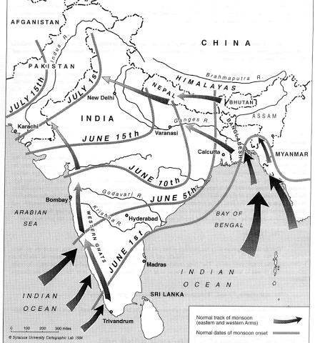
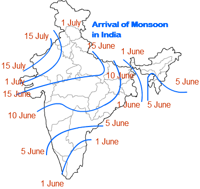
The temperatures in the country are rising every day as a part of the annual march of the weather, this indicates that the summer season is upon us. Meteorologically we are in the Pre –Monsoon season now. Every aviator will recall that in our ground school we were taught that as for as India is concerned this season is the most hazardous season for aviation, and by our experience, we all know how true it is. Therefore it is not too late in the season to refresh a thing or two about the Pre Monsoon season with respect to India. The months of March, April, and May are the months of Pre –Monsoon. But in practice, it is true of Peninsular India only. As for as most of North India is concerned the month of June is also a part of the pre-monsoon season. The main reason for this is that the normal date of onset of monsoon over Kerala is 1st June signaling the end of the Pre-monsoon season over India on 31st May. But as the monsoon progresses in spurts over India it covers the whole country by 15 July, practically barring West Rajasthan, monsoon sets in over the whole country by 1st July. Therefore the month of June will experience typical Pre Monsoon weather wherever the monsoon is yet to set in.
All over the world (Northern Hemisphere) August is supposed to be the hottest month of the year but it is not true for India. In India, the month of May is the hottest month. The reason being that as the monsoon starts setting in, the resultant clouding and rains bring down the maximum temperature considerably. Even over North India where the monsoon has not yet arrived though the maximum temperature is in 40s, increased episodes of thunderstorms/ dust storms help bringing down the average temperature lower in June than that of May. But the weather remains inhospitable as for as flying is concerned.

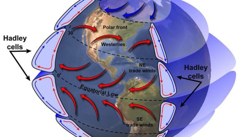
The pre-monsoon season is basically a transition period in the annual cycle of weather from winter to monsoon. In this season the high-pressure area of winter over the northwest of the country is gradually replaced by the establishment of a heat low over the northwest of the country. This low is instrumental in driving the monsoon current to India. As the monsoon gets established over the country this low-pressure area over NW India comes to be known as seasonal low. A trough from this low pressure along the Indo- Gangetic plains to North Bay of Bengal (a.ka Head Bay) is called seasonal trough and as the monsoon sets in, is referred to as the axis of Monsoon trough. So this being a transitional season wherein the pressure pattern is in the process of reversing, it is but natural to have a flat or weak pressure gradient over the country. This should result in light variable winds over the country. However, during the daytime, it is quite common to have strong winds due to solar heating and winds from higher levels descending to the ground. This is also the season when the land and sea breeze effect is most pronounced along the coastal regions of the country. The sea breeze helps in controlling the upward journey of the mercury during the daytime over places like Mumbai, Kochi, Chennai, etc. However, the effect of the sea breeze is limited to about 40 km of the coast, depending on the terrain. That is why the land and sea breeze phenomenon is classified under the category of local winds. In general, the sea breeze sets in by 1100 hrs and is felt as a welcome relief in the form of a cool and moist breeze. One suddenly gets the scent of the ocean. It is because of this reason the maximum temperature over places like Mumbai, Goa, etc does not touch 40C. But if due to synoptic reasons the sea breeze gets late it does become quite uncomfortable as the maximum temperature rises higher on such days. You might have also noticed that generally, the maximum temperatures along the East coast of India are generally higher than that of the west coast. It is mainly due to the fact that the prevailing pressure pattern is conducive for westerly surface winds along the west coast which help in the early setting in of sea breeze. But a westerly surface wind along the east coast opposes the setting in of sea breeze as the sea is to the east. A sea breeze to be felt over places like Chennai has to be strong enough to overcome the westerly wind due to the prevailing pressure distribution so that the resultant surface wind is easterly. This often results in a delayed onset of sea breeze compared to over the west coast. And the temperature will keep rising till the time sea breeze sets in. On some days the sea breeze just does not set in resulting in a very hot and humid day over the coastal cities and the temperature may even touch 40C. The sea breeze is also responsible for clouding inland (slightly away from the coast) during the daytime.

This is a season of thunderstorms/ kalbaishakhis (Norwesters) and Andhis over different parts of the country. Over peninsular India, from April onwards mid-afternoon /evening thunderstorms are common. Due to differential heating of land and sea, as the day progresses, moist winds from the Bay of Bengal and the Arabian Sea start moving inland. These moist easterly and westerly winds converge along a roughly north-south line in the peninsula causing convergence along this discontinuity line. This results in thunderstorm activity over the peninsula during late afternoon or evening hours reducing the severity of the heat over that region. As a matter of fact, as the sun travels northward in this season so does the zone of the highest temperatures. As the season progresses heatwave is experienced over erstwhile Andhara Pardesh and it gradually travels to Orissa and Jharkhand areas and then shifting NW wards toward Bihar UP and finally Rajasthan. In peninsula at places like Bangaluru and Coimbatore the heat moderates from mid-March- April onwards. This happens due to the formation of convective clouds around noon onwards, reducing the total duration of sunshine and as a result lower maximum temperatures. The season also witnesses kalbaishakhis or Norwesters over Eastern India. These are violent thunderstorms that occur in Bihar, Jharkhand, and West Bengal from mid-April onwards. Due to extreme heating and underlying surface Chhota Nagpur region becomes a potentially fertile ground for the formation of Cb clouds. Due to a rise in surface temperature, the atmosphere becomes unstable, and if due to a favorable synoptic situation there is an incursion of moisture from the Bay of Bengal towering CU/Cb clouds form. At the higher levels jet or near Jet stream strength winds still exist. These conditions facilitate the growth of CB clouds up to tropopause heights making it impossible for aircraft to penetrate. The steering currents being North Westerly these clouds move in a SEly direction. Since they approach a station from NW they are called Norwesters. It is quite common to have a clear sky in the morning and suddenly in the afternoon a black line can be seen emerging over the west/northwestern horizon and within half an hour the whole place is under a severe squall and thundershowers. Due to the great vertical growth of these clouds, the squalls are very violent and because of their strength and destruction caused, they are locally called Kalbaishakhis, as the occurrences of such storms start in the month of Baisakh (mid-April onwards). Once formed they move very rapidly SEwards mainly due to regeneration and affect Kolkata mostly by evening. Over the whole of Northeast also this is a season of thunderstorms. The formation starts in the afternoon and the thunderstorm can continue throughout the night. In NE sometimes the problem is not whether to forecast the occurrence of thunderstorms, it is rather when it will not occur. Some airfields in NE can get thunderstorms more than 20 days in the month of May. The good part is that because of thunderstorm activity the maximum temperatures remain mostly around 30C.Over Guwahati the average maximum temperature for the month of Apr and May is 30.6 and 31.4 respectively, for Dibrugarh it is 27.4 and 29.8 and at DumDum airport it is 35.3 for both the months. The average number of thunderstorms in Guwahati is 10 in April and at DumDum it is 10(9.6). In comparison, Delhi has an average temperature of 39.5 &39.2 in May and June respectively. But Eastern India despite having lower maximum temperatures can become extremely uncomfortable due to the high level of humidity. In the north and NW India, this season presents with twin hazards of poor visibility including in-flight and Dust storms or Andhis as they are locally known. Due to a prolonged dry season and increasing heat, the earth’s crust is totally dry, and therefore plenty of loose soil particles are available. These soil particles are carried upward by wind and they remain suspended for a number of days reducing visibility on the surface as well as in flight. As the heat increases the pressure gradient also increases and whenever a western disturbance is transiting across North India, the pressure gradient becomes steeper resulting in increased surface wind speed which carries loose dust upwards to great heights. The resultant visibility can decrease to even lower than one Km. Also, SWly wind carry dust and sand from Rajasthan adding to the woes of the aviators. A transiting WD can generate Cb clouds. The squalls from these clouds kick up loose dust from the surface giving rise to dust storms. As the ambient humidity is less these CB clouds do not carry too much rain therefore on many occasions hardly any rainfall occurs as a lot of raindrops evaporate before reaching the ground. The basic problem is that due to widespread dust haze it becomes difficult to spot these clouds without the help of a weather radar, thus posing a major in-flight hazard. The visibility in a dust storm can reduce to nil, but the good part is that after a dust storm there is a fall in temperature and visibility improves rapidly. Dust storms bring a welcome break in the heatwave. These conditions prevail till the time monsoon sets in which can be the end of June or the beginning of July over West UP, Delhi Panjab, and Haryana. Over west Rajasthan, it is generally up to 15 July. Thus the premonsoon season is characterized by high temperatures and convective weather practically over the whole country. Over NW India one has to take precautions against exposure to sun and ensure that one is hydrated enough by sufficient intake of fluids.
Thank you, Sir. Just to add the perspective from the flight deck In my view, there are four basic categories of aviation weather threats: low clouds and reduced visibility; turbulence and low-level wind shear; airframe ice; and thunderstorms (which may contain the three other hazards in one nasty package). When evaluating weather I not only take input of METAR and TAF but also input from the weather radar as well as what I see and experience. As I keep approaching weather I always keep updating the weather model based on the knowledge, experience, and information I have collected. I keep analyzing how bad each threat would be and what are my best chances of making a safe landing within my capabilities and those of regulations. Basically, in simple words, I keep evaluating weather-related Go/No Go decisions. Every pilot who has experienced a weather accident near miss always commented that they should not have tried what they were doing. Weather can be hazardous but it is the way the pilot approaches the weather makes decisions safe or unsafe.
“Thunderstorms are as much our friends as the sunshine.”


