Weather occurs at different scales of space and time. The four meteorological scales are: microscale, mesoscale, synoptic scale, and global scale. Meteorologists often focus on a specific scale in their work.
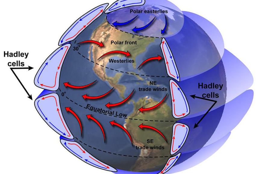
- Planetary scale : Characteristics horizontal length ~ 5000 km, Time 5 days or more. Global scale phenomena are weather patterns related to the transport of heat, wind, and moisture from the tropics to the poles. An important pattern is global atmospheric circulation, the large-scale movement of air that helps distribute thermal energy (heat) across the surface of the Earth.
- Synoptic scale : Characteristics horizontal length ~ 1000 km, Time 1 day. High- and low-pressure systemsseen on local weather forecasts, are synoptic in scale. Pressure, much like convection, is an important meteorological principle that is at the root of large-scale weather systems as diverse as hurricanes and bitter cold outbreaks.
- Meso scale : Characteristics horizontal length ~ 100 km, Time 5 hrs. Two important phenomena are mesoscale convective complexes (MCC) and mesoscale convective systems (MCS). Both are caused by convection, an important meteorological principle.
- Micro scale : Characteristics horizontal length ~ 1 km, Time 10 min. Microscale meteorologists often study the processes that occur between soil, vegetation, and surface water near ground level. They measure the transfer of heat, gas, and liquid between these surfaces. Microscale meteorology often involves the study of chemistry.
In general, larger the horizontal length scale, larger is the time scale.
In this blog we will have a look at Meso scale systems which affect aviation and aviators in general. The Meso scale systems like Thunderstorms are hazardous to aviation in various ways.
- Synoptic scale systems in tropics derive most of their energy through meso-scale systems
- Difficult to capture with synoptic scale observations
- Due to importance of miso-scale systems, international efforts have been made to study the system.
Tropical Convection is Mesoscale in Nature i.e. Horizontal scale of ~ 10 sq km, Vertical extent averaging ~ 15 km, Time scale of about 1-6 hr
It interact with large-scale flow results in the development of mesoscale convective systems like SEVERE THUNDERSTORMS and associated severe weather phenomenon like HAIL STORMS, SQUALL & LIGHTNING.
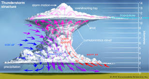
Thunderstorm
- These are the most violent convective systems in the atmosphere and are associated with cumulonimbus (Cb) cloud.
- One of the ingredients needed for thunderstorm development is moisture, preferably in the lower and mid levels.
- Originate mainly over the heated land masses that heats up the air mass above it and initiates convection.
- In India, these thunderstorms reach severity when continental air meets warm moist air from ocean.
- The eastern and north eastern part of the country gets affected by severe thunderstorms mainly during April-May.
- The presence of upper level shear adds severity to the storm since it differentiates the zone of the updraft form the zone of downdraft at this stage. It also extends the life time of the cell.
Moderate Thunderstorm: Loud peals of thunder with frequent lightning flashes, moderate to heavy rains and maximum wind speed 29 to 74 kmph
Severe Thunderstorm : Continuous thunder and lightning, heavy rains and maximum wind speed ≥ 75 kmph
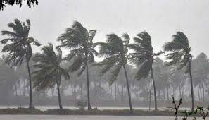
SQUALL: A sudden increase of wind speed by at least 29 kmph (16 kts), the speed rising to 40 kmph (22 kts) or more and lasting for at least one minute. A squall is a sudden, sharp increase in wind speed lasting minutes, as opposed to a wind gust, which lasts for only seconds.
Moderate Squall : Surface wind speed (in gusts) upto 80 kmph
Severe Squall: Surface wind speed (in gusts) > 80 kmph

Hailstorm– Hail is a type of solid rain made up of balls or lumps of ice. Storms that produce hail which reaches the ground are known as hailstorms. They typically last for no more than 15 minutes but can cause injuries to people and damage buildings, vehicles and crops.
Slight Hailstorm : Sparse, usually small size and often mixed with rain
Moderate Hailstorm : Fall abundant enough to whiten ground
Heavy Hailstorm : Includes at least a proportion of large stones.
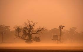
DUSTSTORMS– Sand and dust storms (SDS) occur when strong winds lift sand and dust from dry soils into the atmosphere, transporting particles over vast distances.
- Duststorms, which are raised dust in the air occur only in the plains of Northwest India. Locally these are known as ‘ANDHIS’.
- Duststorm activity starts in April and continues up to June. Their frequency of occurrence is at maximum in June.
- On a few occasions duststorms are followed by thundershowers.
- Intense surface heating, western disturbances and westerly trough are the causes of duststorms.
Duststorms may be categorized into two types namely
(i) The Pressure Gradient Type and (ii) The convective type.
- Pressure gradient type thunderstorm: When the seasonal low pressure area over NW India becomes marked strong gradient builds up to the south of the low causing strong winds (about 30 kts). These strong winds raise the dust particles in the air reducing the visibility below 1.0 km such pressure gradient type duststorms occur frequently over Rajasthan in May and June. .
- Convective type thunderstorm: It occurs in the later part of the day or night. In this type of duststorms the dust particles are raised by the down draft winds of Cb-clouds in such cases the dust particle may go up to a height of 2 to 3 kms. Convective type duststorms often go before thunderstorms.
KALBAISAKHS/NORWESTERS- Kalbaisakhi bring destruction by uprooting trees due to gale winds and waterlogging roads due to heavy rainfall. It often damages crop by hailstorms. However it is extremely helpful for kharif crops like jute, paddy, etc.
The eastern and northeastern parts of our country i.e Gangetic West Bengal, Jharkahand, Bihar, Orissa, and States in NE India get affected by severe thunderstorms during pre-monsoon months of March to May.
These storms usually travel from northwest to southeast direction and are called “Norwesters”. They are locally known as “Kalbaisakhi”. These severe thunderstorms have very significant socioeconomic importance for eastern and northeastern parts of the country.