Thunderstorm is a severe weather phenomenon, the impact of which is being increasingly felt by all the sectors of society.
A knowledge of the thunderstorm climatology with respect to its frequency of occurrence, intensity, diurnal variation and duration is essential particularly in the interest of safe air navigation. In this blog we will look at distribution of thunderstorm activity in Indian region. This will help pilots, dispatchers, controllers and operators to understand most active areas and routes falling in those areas.
“Thunderstorms: nature’s ultimate light show.”
Thunderstorm is one of the most spectacular weather phenomenon offered by nature. Giant cumulus cloud developing into a towering dark cumulonimbus accompanied with lightning flashes and thunder is a sight to watch. During summer season common man looks at the majestic and towering thundery cumulonimbus with hope, because of the oncoming showers to provide relief from scorching heat. While farmers welcome thunderstorm for rains and consequent benefits, the aviator dreads it and tries to keep away from it, as thunderstorm is a well known hazard to aviation and a large percentage of aircraft weather related accidents have been due to thunderstorms. Most of the high impact weather phenomenon on mesoscale like hailstorm, heavy rain and squalls are caused by thunderstorms.
Impact of Thunderstorms in India
- Severe Thunderstorm activity during pre-monsoon and monsoon period.
- Most tornadoes are associated with Kalbaisakhs.
- India has highest frequency of hailstorms in the world.
- India has highest casualty associated with lightning strike.
- Frequency of occurrence of thunderstorms in India is second only to that in central regions of United States.
- Major aviation hazard with several incidents and accidents.
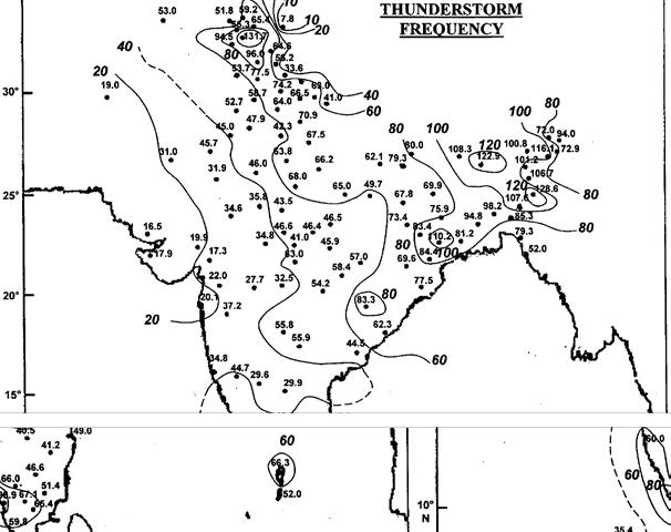
Annual Frequency
- The areas of highest activity of thunderstorms exceeding 120 days in the year are seen over Assam, Sub Himalayan West Bengal and windward side of Pir Panjal range in Jammu and Kashmir.
- The region of high thunderstorm activity (more than 100 days) are Jammu sub-division in the north-Assam, Meghalaya and adjoining parts of Bangladesh and West Bengal in the east followed by Kerala ( 80-100 days).
- Least number of thunderstorms (5 days) in the country occur in Ladakh.
- In the plains, lowest occurrence is seen over Saurashtra and Kutch (15 days). Thunderstorm activity increases as one moves north eastwards from Saurashtra and Kutch across Rajasthan (20 to 40 days), Haryana (40 to 50 days), Punjab and Uttar Pradesh (50 to 70 days) to Himalayan foothills (80 days).
- The frequency of thunderstorm over central parts of country is between 30 and 50 days. The frequency increases eastwards and is between 50 and 80 days over Bihar, east Madhya Pradesh, Chhatishgarh, Telangana and coastal Andhra Pradesh and Orissa. The frequency increases to 80 to 100 days over Gangetic West Bengal and Bangladesh and between 100 and 120 days over Sub- Himlayan West Bengal, Assam and adjoining northeastern states.
- Thunderstorm frequency is between 20 and 40 days over Madhya Maharashtra, Rayalseema and adjoining north Karnataka and shows increase southwards.
- The frequency is between 40 and 60 days over Karnataka and northern parts of Tamil Nadu and between 60 and 80 days over Kerala and adjoining south Tamil Nadu. Bay islands record between 50 and 70 days of thunderstorm activity.
Seasonal Distribution
Winter
- Country as a whole records the lowest number of thunderstorms during winter season. It is primarily due to stable and dry atmospheric conditions prevailing over most parts of the subcontinent with the exception of Srilanka and southern Kerala.
- Highest frequency during this season is over Sri Lanka (16 days) associated with northeast monsoon activity.
- Second maxima (13 days) is seen over windward side of Pir Panjal range over Jammu and adjoining region. This maxima is associated with western disturbances.
Pre Monsson
- Pre monsoon season is characterised by increase in thunderstorm activity over all parts of the country with significant increase over northeast India, Bangladesh, West Bengal, south peninsula and Jammu region.
- Highest frequency of more than 40 days is observed over Meghalaya and adjoining Assam, Sub-Himalayan West Bengal and Kerala and more than 30 days over rest of northeast India and parts of Bangladesh and West Bengal.
- In the north, Jammu sub-division records highest frequency (25-30 days) of thunderstorm in the pre monsoon season. Topography, insolation and advection of moisture under favourable wind regime contribute to thunderstorm maxima over these areas.
- In the plains, the lowest frequency of 2 to 3 days is observed over Gujarat and between 5 and 10 days over Rajasthan, West Madhya Pradesh and north Maharashtra and between 10 and 15 days over Indo Gangetic plains and rest of peninsula.
- Thunderstorm frequency increases to 15-20 days over East MP, Chhatishgarh, Orissa and adjoining parts of Andhra. Thunderstorms occur between 20 and 30 days over West Bengal and adjoining Jharkhand and Orissa, South Tamil Nadu and Karnataka.
Monsoon
- Country as a whole outside Kerala records the highest frequency of thunderstorms during monsoon season. Availability of moisture and favourable synoptic features contribute to general increase of thunderstorm activity over all parts of the country outside Kerala.
- The highest thunderstorm activity in the country continues to be over northeastern states, Bangladesh, West Bengal and adjoining states, which record more than 50 days of thunderstorm during the season with maxima of 70 days over Sub-Himalayan West Bengal.
- Most of thunderstorm activity over Rajasthan, Gujarat, Madhya Pradesh and northern parts of Maharashtra is caused by westward moving monsoon lows and depressions whereas over Tamil Nadu, Andhra Pradesh and adjoining areas thunderstorm occur during weak/break monsoon conditions.
Post Monsoon
- Country witnesses marked decrease in thunderstorm activities.
- Thunderstorm activity increases as one moves southwards along west coast and east coast.
- Highest number of thunderstorms during this season occur over Kerala (20 to 25 days) whereas neighbouring state Tamil Nadu has frequency of 10 to 15 days. Higher activity over south peninsula is associated with retreating monsoon and easterly waves.
Remember, as you head east and north in India, the frequency increases. The other hot spot being coastal peninsular region of the country. Thunderstorm can form at any time, in any season and in any place but there are hot spots and risky seasons as covered in the blog above. Every pilot should know about them. Line Squalls/Severe storms (Kalbaisakhs) are more likely to be found in month of Apr to Jul in eastern part of the country.
Avoiding Thunderstorms
- The short and easy answer is : Just don’t get into the storm to begin with. Keep more than 20 miles of distance from big cells. Farther is better.
- The only way to avoid the threat of microbursts is to avoid storm cells on approach or take off path. Despite ample caution these incidents keep happening.
- Extreme turbulence, severe icing, hail loss of situation awareness, over stressing of aircraft and lightning are various hazards in the storm. More often a simple turn around is the best solution.
- Wise use of available information, judicious use of aids are the first line of defence.
- Trying to find gaps could be tricky and dangerous.
- Understand the stage of thunderstorm by looking at its size, colour and edges.
- Keep diversion as a plan always ready when negotiating large areas of convective weather. Divert before it’s an emergency.
Good Luck.
Good luck in aviation comes with planning and patience. Do not skip the preflight weather brief. Take a long look at en-route weather and airports along the way. Any changes in the weather along the route and en-route airfields should ring alarm bells.
India Meteorological Department
IMD is the principal government agency of Government of India for all weather and climate services. It functions under Ministry of Earth Sciences (MoES) with its headquarter at Mausam Bhawan, Lodhi Road, New Delhi. It has six regional centres and 26 meteorological centres at state level. The India Meteorological Department was established in 1875 with HF Blanford as Meteorological Reporter. From the modest beginning in 1875 to at present, IMD boasts of 39 Doppler Weather Radars for better observation and prediction of extreme events across the country by 2023, along with INSAT 3D/3DR dedicated weather satellites providing every 15 minutes cloud imagery. About 200 Agro-Automated Weather Station (Agro- AWS), 806 Automatic weather stations, 1382 Automatic Rain gauges, 83 lightning sensors along with 63 Pilot balloon upper air observation stations serve as the backbone of weather observation services of IMD throughout the country. And true to its growth, I have been witness to increasing accuracy, reliability of forecast and trend. IMD range of services has also expanded enormously to sectors like Agriculture, Aviation, Shipping, General Weather, Hydrology, Power, Health, Transport etc.
Reference:
1. Evolution of Indian Meteorological Department, https://rsmcnewdelhi.imd.gov.in/images/pdf/Evolution_of_IMD.pdf
2. Thunderstorms, Naresh Kumar, IMD.
3. Thunderstorm Climatology over Indian Region, Ajit Tyagi, Mausam,